Precision in Every Survey
Groundwater exploration requires more than guesswork – it demands accuracy, depth, and proven science. Our geophysical surveys use advanced water detection methods to locate and characterize aquifers with high certainty, helping landowners, developers, and institutions in Kenya reduce the risk of drilling dry or unproductive boreholes.
Our working method
- Site Assessment – We review geological maps, borehole records, and satellite imagery to plan the most effective survey lines for groundwater detection.
- Instrument Setup – Sensors are deployed strategically across the site to ensure wide subsurface coverage and reliable data.
- Data Collection – The system passively records natural electromagnetic field variations, penetrating to depths that many standard resistivity surveys cannot reach.
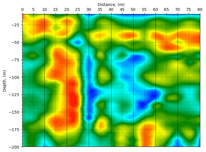
- Data Analysis & Interpretation – Specialized software transforms the readings into clear geological profiles, highlighting water-bearing zones, fractures, and faults.
- Validation – When results raise questions, we return for additional scans or cross-check with complementary geophysical methods. This thoroughness prevents costly drilling mistakes.
Why Our Methods Stand Out
Non – invasive
No excavation or ground disturbance.
Deep penetration
Locates aquifers far beyond shallow resistivity limits.
Fast and efficient
Multiple survey points can be completed in a single day.
Reliable outcomes
Data-driven insights improve drilling success rates.
Our Commitment to Quality
We believe in accuracy over convenience. On one project, we re-surveyed a site over 500 km away after post-analysis showed uncertainties. That level of dedication means clients can trust our surveys to guide groundwater development decisions with confidence.