How control surveys, local geology, and expertise shape reliable groundwater mapping
Groundwater mapping requires more than merely deploying instruments and collecting data; it demands a delicate blend of science, experience, and local insight. Whether you explore aquifers in Busia County or chart subsurface layers in volcanic terrains, several factors determine the success of a geophysical survey:
🔍 Groundwater mapping and interpretation challenges
Geophysical methods like magnetotelluric (MT) and electrical resistivity tomography (ERT) offer powerful tools for groundwater exploration. MT measures natural variations in the Earth’s electromagnetic field to infer subsurface resistivity, whereas ERT injects current into the ground and measures voltage differences to map resistivity profiles.
However, resistivity does not measure water directly; rather, it reflects several factors such as mineral content, porosity, salinity, clay presence, and temperature. Consequently, when you observe a low-resistivity zone, you must ask: Does it represent water-saturated sand or a clay-rich layer with similar electrical properties? Without geological context, you risk misinterpreting the data.
The golden rule is this: Always question whether the method detected water or something else entirely.
🧪 Groundwater Mapping and Control Surveys Build Confidence
One of the most effective ways to validate geophysical interpretations is through control surveys. This involves conducting a survey near a borehole with well-documented lithology and hydrogeological properties.
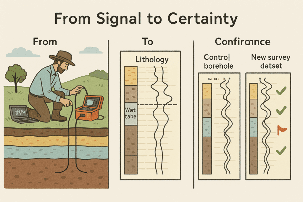
How It Works:
📍 Location Selection: Choose a borehole with known stratigraphy and water table depth.
📊 Survey Execution: Run MT or ERT surveys adjacent to the borehole.
🔁 Data Comparison: Match geophysical signatures with borehole logs.
🧭 Model Calibration: Use this reference to interpret new data in geologically similar areas.
This approach helps reduce false positives, refine inversion models, and build confidence in the results – especially in regions with complex geology like Kenya’s rift zones or volcanic provinces.
💡 Final Thought on groundwater mapping
Groundwater mapping isn’t just a technical exercise – it’s about providing communities with access to clean, reliable water. Whether it’s for drinking, farming, or industry, getting it right can transform lives. But a misstep, like drilling in the wrong spot, can waste time, money, and hope. By combining cutting-edge geophysical methods, skilled operators, a deep understanding of local geology, and the validation of control surveys, we can unlock the Earth’s secrets with precision and confidence.